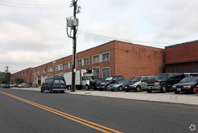
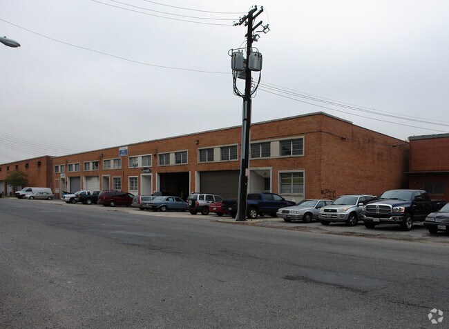
Property Record
2910 V St Ne, Washington, DC 20018

NEARBY LISTINGS FOR SALE OR LEASE
Property Detail
2910 V St Ne
Washington-Arlington-Alexandria, DC-VA-MD-WV
Woodridge
4365-0809
SQUARE 4365 LOT 0809 NBHD: WOODRIDGE
Warehouse
District of Columbia
X
District of Columbia
24033C0137E
809
2025
1 AC
2025
NE
011100
Washington, DC
38,322 SF
DEMOGRAPHICS near 2910 V St Ne
1 Mile
3 Mile
5 Mile
2024 Total Population
13,851
252,793
749,754
2029 Population
12,569
235,643
701,377
Pop Growth 2024-2029
(9.26%)
(6.78%)
(6.45%)
Average Age
40
37
37
2024 Total Households
5,399
108,079
319,915
HH Growth 2024-2029
(10.24%)
(7.58%)
(7.48%)
Median Household Inc
$68,142
$82,826
$86,137
Avg Household Size
2.20
2.20
2.20
2024 Avg HH Vehicles
1.00
1.00
1.00
Median Home Value
$656,304
$595,874
$519,345
Median Year Built
1961
1955
1960
Nearby Places
Map Layers
Map Styles
 Street
 Aerial
- Restaurants
- Banks
- Shops
- Fitness
- Groceries
PUBLIC TRANSPORTATION
COMMUTER RAIL
Union Station (Red Line - Washington Metropolitan Area Transit Authority Metrorail (Metrorail))
DRIVE
WALK
Distance
Union Station (Red Line - Washington Metropolitan Area Transit Authority Metrorail (Metrorail))
7 min
3.3 mi
DRIVE
WALK
Distance
7 min
3.3 mi
AIRPORT
Ronald Reagan Washington Ntl
DRIVE
WALK
Distance
Ronald Reagan Washington Ntl
19 min
8.9 mi
Baltimore/Washington International Thurgood Marshall
DRIVE
WALK
Distance
Baltimore/Washington International Thurgood Marshall
41 min
27.7 mi
Washington Dulles International
DRIVE
WALK
Distance
Washington Dulles International
52 min
31.5 mi
Freight Ports
Port of Baltimore
DRIVE
WALK
Distance
Port of Baltimore
50 min
34.0 mi
Nearby Properties
Address
Land Use
TOTAL SIZE
Lot Size
Zoning
Address
Land Use
TOTAL SIZE
Lot Size
Zoning
58,289 SF
418.97 AC
MU-4;PDR-1
Address
Land Use
TOTAL SIZE
Lot Size
Zoning
1,583,364 SF
276.66 AC
UNZONED
Address
Land Use
TOTAL SIZE
Lot Size
Zoning
1,043,058 SF
4.03 AC
UNZONED
Address
Land Use
TOTAL SIZE
Lot Size
Zoning
607,735 SF
8.94 AC
PDR-3;UNZO
Address
Land Use
TOTAL SIZE
Lot Size
Zoning
1,562,988 SF
15.33 AC
MU-10 (IZ+
Address
Land Use
TOTAL SIZE
Lot Size
Zoning
1,642,951 SF
95.12 AC
RF-1
Address
Land Use
TOTAL SIZE
Lot Size
Zoning
95.32 AC
RA-1
Address
Land Use
TOTAL SIZE
Lot Size
Zoning
730,233 SF
4.78 AC
UNZONED
Address
Land Use
TOTAL SIZE
Lot Size
Zoning
314,995 SF
5.83 AC
D-5
Address
Land Use
TOTAL SIZE
Lot Size
Zoning
7.41 AC
UNZONED
Address
Land Use
TOTAL SIZE
Lot Size
Zoning
1,323,000 SF
3.36 AC
RA-2
Address
Land Use
TOTAL SIZE
Lot Size
Zoning
21.28 AC
GOV
Address
Land Use
TOTAL SIZE
Lot Size
Zoning
1,835,827 SF
34.66 AC
UNZONED
Address
Land Use
TOTAL SIZE
Lot Size
Zoning
489,139 SF
1.75 AC
D-3
Address
Land Use
TOTAL SIZE
Lot Size
Zoning
589,000 SF
1.39 AC
D-5
Address
Land Use
TOTAL SIZE
Lot Size
Zoning
1,239,708 SF
2.21 AC
D-3
Address
Land Use
TOTAL SIZE
Lot Size
Zoning
5.53 AC
UNZONED
Address
Land Use
TOTAL SIZE
Lot Size
Zoning
791,730 SF
37.44 AC
RA-1
Address
Land Use
TOTAL SIZE
Lot Size
Zoning
169.85 AC
R-2;RA-1;U
Address
Land Use
TOTAL SIZE
Lot Size
Zoning
6.54 AC
MU-4;RF-1
Address
Land Use
TOTAL SIZE
Lot Size
Zoning
823,802 SF
7.30 AC
MU-2
Address
Land Use
TOTAL SIZE
Lot Size
Zoning
812,092 SF
10.19 AC
UNZONED
Address
Land Use
TOTAL SIZE
Lot Size
Zoning
726,490 SF
3.84 AC
RA-2
Address
Land Use
TOTAL SIZE
Lot Size
Zoning
1,408,414 SF
4.19 AC
D-4
Address
Land Use
TOTAL SIZE
Lot Size
Zoning
572,916 SF
1.26 AC
UNZONED
Address
Land Use
TOTAL SIZE
Lot Size
Zoning
2,985,682 SF
4.33 AC
RSF65
Address
Land Use
TOTAL SIZE
Lot Size
Zoning
186,952 SF
9.46 AC
RA-2;RF-1
Address
Land Use
TOTAL SIZE
Lot Size
Zoning
1,059,397 SF
2.51 AC
PDR-3;USN
Address
Land Use
TOTAL SIZE
Lot Size
Zoning
0.97 AC
D-3
Address
Land Use
TOTAL SIZE
Lot Size
Zoning
545,000 SF
0.81 AC
D-5
The World's #1 Commercial Real Estate Marketplace
Connect with us
© 2025 CoStar Group
The information above has been obtained from sources believed reliable. While we do not doubt its accuracy we have not verified it and make no guarantee, warranty or representation about it. It is your responsibility to independently confirm its accuracy and completeness. Any projections, opinions, assumptions, or estimates used are for example only and do not represent the current or future performance of the property. The value of this transaction to you depends on tax and other factors which should be evaluated by your tax, financial, and legal advisors. You and your advisors should conduct a careful, independent investigation of the property to determine to your satisfaction the suitability of the property for your needs.